
Introduction
Have you ever wanted to see how a coastline looked ten years ago? Or maybe you needed satellite data for a school project and had no idea where to start. This is exactly where USGS EarthExplorer comes in handy.
USGS EarthExplorer is a free online platform built by the U.S. Geological Survey. It lets you search, view, and download satellite imagery and geospatial data without spending a single dollar. Whether you are a student, a GIS professional, or just someone curious about our planet, this tool opens a window into Earth’s history that most people never knew existed.
In this article, I will walk you through everything you need to know about USGS EarthExplorer. You will learn what it offers, how it works, who benefits from it, and how you can start using it today. By the end, you will understand why so many scientists and researchers trust this platform for their daily work.
What Is USGS EarthExplorer?
USGS EarthExplorer is a web based tool that gives you access to decades of Earth observation data. It was created by the United States Geological Survey to make satellite imagery and geospatial datasets available to the public.
Think of it as a massive digital library. Instead of books, it holds millions of satellite images, aerial photos, and elevation maps. You can search this library based on location, time period, and dataset type.
The best part is that most of this data comes at no cost. You simply create a free account, search for what you need, and download it directly to your computer.
What Can You Find on EarthExplorer?
EarthExplorer hosts a huge variety of datasets. Here are some of the most popular ones you will find on the platform.
- Landsat Imagery captures satellite images going back to the 1970s, perfect for tracking long term changes.
- Aerial Photography offers high resolution images captured by aircraft, often used for detailed local studies.
- Digital Elevation Data provides terrain and elevation models that help with mapping and 3D modeling.
- Land Cover Data shows how land use has shifted over time, such as forests turning into farmland.
- Radar and Thermal Data supports specialized studies like weather patterns and temperature analysis.
This wide range makes USGS EarthExplorer valuable across many fields, from agriculture to disaster response.
How Does EarthExplorer Work?
Using USGS EarthExplorer might sound technical at first, but it is actually quite simple once you get the hang of it. The platform is built around a few easy steps.
Step 1: Define Your Area of Interest
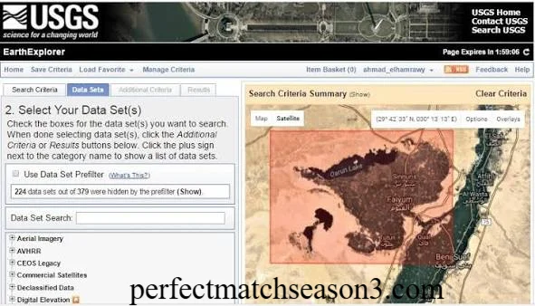
You start by selecting a location on the interactive map. You can type in an address, drop a pin, or draw a boundary around your area of interest.
Step 2: Set Your Date Range
Next, you choose the time period you want to explore. This step is especially useful when comparing older and newer images of the same place.
Step 3: Choose Your Dataset
USGS EarthExplorer offers dozens of dataset categories. You can narrow your search based on what type of imagery or data fits your project.
Step 4: Apply Filters
You can further refine results using filters like cloud cover percentage. This helps you avoid images that are blocked by clouds and unusable for analysis.
Step 5: Download Your Data
Once you find the right image or dataset, you simply add it to your cart and download it. Many files are available instantly, while some larger datasets may take a bit longer to process.
Is USGS EarthExplorer Free?
Yes, and this is one of the biggest reasons people love this platform. Most datasets on USGS EarthExplorer can be searched and downloaded completely free of charge.
You do need to register for a free account before downloading files. This registration simply helps USGS track usage and manage server resources. There are no hidden fees or subscription plans required for standard access.
This free access sets USGS EarthExplorer apart from many commercial satellite imagery providers that charge high prices for similar data.
Who Uses EarthExplorer?
USGS EarthExplorer serves a wide audience across different industries and interests. Here is a quick look at who benefits most from this tool.
- Researchers and Scientists rely on it for climate studies, environmental monitoring, and academic research.
- GIS Professionals use it to build maps and conduct spatial analysis for various projects.
- Students find it helpful for school assignments, thesis work, and learning about remote sensing.
- Environmental Analysts track deforestation, urban growth, and natural disasters using historical imagery.
- Government Agencies use the data for planning, agriculture monitoring, and disaster response.
If your work or studies involve understanding changes on Earth’s surface, this platform likely has something useful for you.
Why EarthExplorer Matters for Remote Sensing and GIS
USGS EarthExplorer plays a major role in the world of remote sensing and GIS mapping. It gives you access to data that would otherwise require expensive equipment or paid subscriptions.
Landsat imagery available on the platform is particularly valuable. You can use it to study changes in forests, agriculture, cities, coastlines, and water bodies over many decades. This long historical record is something few other free platforms can match.
I have personally used similar satellite tools for small research projects, and I can tell you that having access to decades of imagery in one place saves enormous amounts of time. Instead of contacting multiple agencies or paying for commercial data, you get everything through a single, organized search interface.
Comparing Historical and Recent Imagery
One of the most powerful features of USGS EarthExplorer is the ability to compare old and new images of the same location. This comparison reveals changes that are often invisible in everyday life.
For example, you could pull up satellite images of a city from 1985 and compare them to images from today. You would likely see new highways, expanded neighborhoods, and shrinking green spaces. This type of comparison is incredibly useful for urban planners, environmental groups, and even journalists investigating land use stories.
Coastal researchers also use this feature to track erosion patterns. By comparing shoreline images across several decades, they can predict future risks and plan protective measures.
Tips for Getting the Most Out of EarthExplorer
If you want to use USGS EarthExplorer effectively, keep these practical tips in mind.
- Start with a small, specific area of interest rather than a huge region, since this speeds up your search results.
- Use the cloud cover filter to avoid downloading images that are mostly obscured.
- Check multiple datasets since different sensors capture different details.
- Save your searches so you can quickly return to them later.
- Read the metadata carefully before downloading, as it tells you the exact date and quality of each image.
These small habits can save you hours of frustration and help you find exactly what you need faster.
Conclusion
USGS EarthExplorer stands out as one of the most valuable free resources for anyone interested in satellite imagery and Earth science. It gives you access to decades of Landsat imagery, aerial photography, elevation data, and much more, all without any cost.
Whether you are a student working on a research paper, a GIS professional building detailed maps, or simply someone curious about how our planet has changed, USGS EarthExplorer has something for you. The platform makes it easy to search by location, date, and dataset while comparing historical and recent imagery side by side.
Have you tried USGS EarthExplorer yet? If not, this might be the perfect time to explore it for your next project. And if you already use it, feel free to share your favorite tips with others who are just getting started.
Frequently Asked Questions
Is USGS EarthExplorer really free to use? Yes, most datasets on USGS EarthExplorer are free to search and download after you create a free account.
Do I need special software to use EarthExplorer? No special software is required to search and download data. However, viewing certain file formats like GeoTIFF may require GIS software such as QGIS.
How far back does the satellite imagery go? Landsat imagery on USGS EarthExplorer dates back to the 1970s, offering one of the longest continuous satellite records available.
Can beginners use USGS EarthExplorer without GIS experience? Yes, the interface is designed to be user friendly, and beginners can search and download basic imagery without advanced technical knowledge.
What file formats does EarthExplorer provide? Common formats include GeoTIFF, JPEG, and other standard geospatial file types depending on the dataset you choose.
Is registration required to download data? Yes, you need to create a free USGS account before downloading most datasets on EarthExplorer.
Can I use EarthExplorer data for commercial projects? Many datasets are in the public domain and free for commercial use, though it is wise to check specific licensing details for each dataset.
What is the difference between EarthExplorer and Google Earth? Google Earth focuses on visual exploration, while USGS EarthExplorer provides raw, downloadable data suitable for scientific analysis and GIS work.
perfectmatchseason3.com
Author Name: Hamid Ali
Email: johanharwen314@gmail.com
About the Author: Hamid Ali is a content writer with a strong interest in GIS, remote sensing, and environmental technology. He enjoys breaking down technical topics into simple, practical guides that help everyday readers understand powerful tools like USGS EarthExplorer.